Streamlining Land Survey with GIS Solution: Automating Drone Image Processing
Categories: AIML, Digital Transformation
Share On:
The effective development of agricultural production makes it necessary to introduce highly efficient technologies for collecting and processing land information. Information technologies can be of significant help in solving numerous problems.
The main purpose of GIS in land management is the creation of digital maps and plans of the area. The use of GIS technologies allows for a more complete assessment of land resources. Land management includes a system of state, economic, engineering, and legal measures aimed at the rational use of lands and their protection.
Drone-based assessments have made it much easier to carry out land surveying. The land management digitalization project is a complex systemic task that affects the content of land management and the entire land management system of the country. The digitalization of land management cannot be carried out without creating a single integrated information system.
GIS technologies allow us to work with maps, diagrams, and graphs to identify the main problems and develop solutions. Our GIS platform technology provides a comprehensive set of automation tools for land parcel management based on drone images of agricultural land and rural areas. This will ensure the implementation of a long-term strategy for structuring the land market. The development and implementation of digital technologies will open a strategic area for the automation and optimization of land management design processes and the implementation of rural development projects.
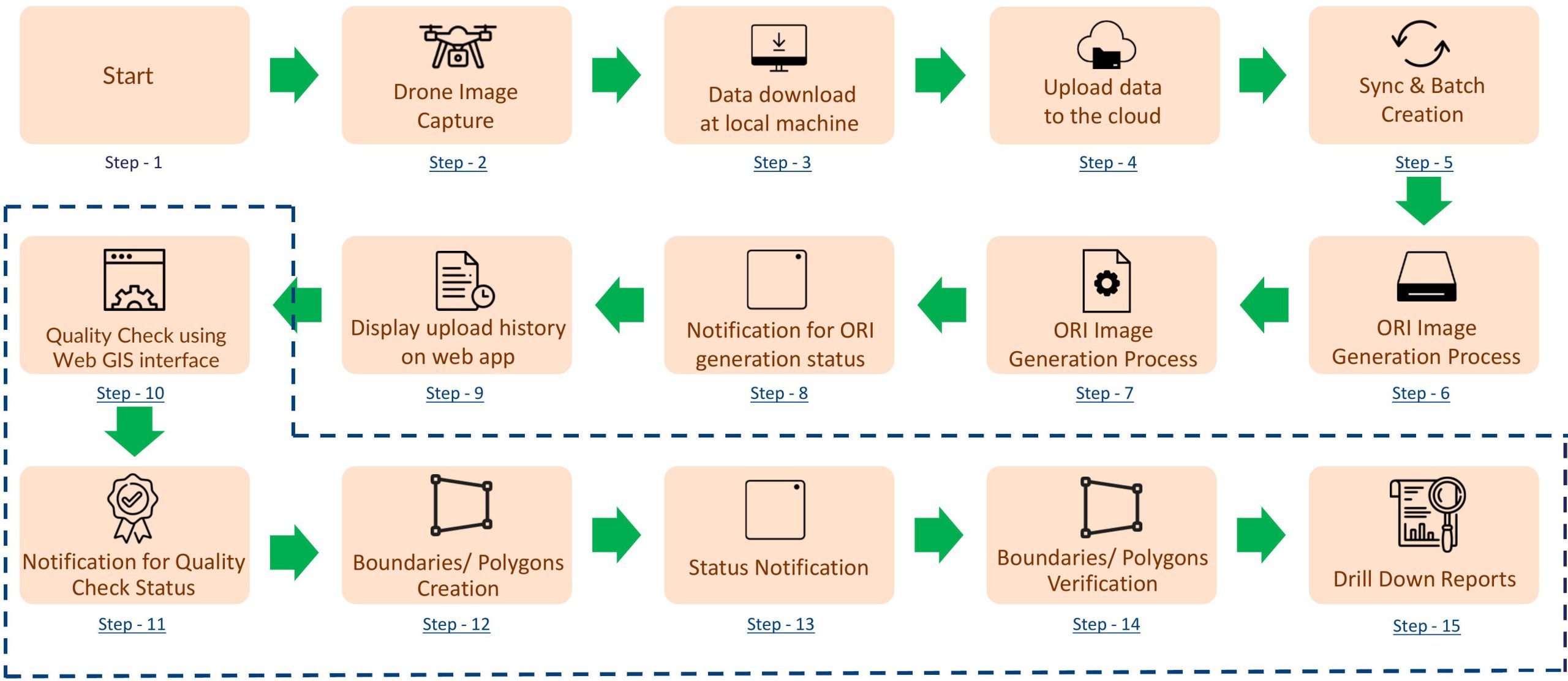
GIS PROCESS FLOW
Synchronization of Drone Images
GIS simplifies the process of synchronizing drone images from a local PC to a centralized server.
By automating this data transfer, it eliminates the need for manual intervention, reducing human error
and saving valuable time. The seamless synchronization enables real-time access to the latest drone images
for further analysis.
Orthomosaic Image Generation
With the synchronized drone images, GIS utilizes advanced algorithms to generate high-resolution
orthomosaic images. Orthomosaics are composite images created by stitching together multiple aerial images,
providing a detailed and accurate representation of the surveyed area. These images serve as a foundation
for further analysis and decision-making in land surveying.
Web GIS Interface for Quality Check and Boundary Creation
Our GIS offers a web GIS interface that allows users to perform quality checks on the orthomosaic images.
This feature enables surveyors to verify accuracy and identify potential discrepancies. Additionally, the
application provides tools for creating precise boundaries on the orthomosaic images, supporting effective
delineation of land parcels.
Usage of COG Technology
Cloud Optimized GeoTIFF (COG) is a file format for geospatial data optimized for cloud storage and
processing. COG files are smaller and faster to load than traditional GeoTIFF files, making them ideal
for web-based GIS applications.
Verification and Owner Association
In the land surveying process, it is crucial to associate ownership details with created boundaries.
GIS simplifies this by providing an intuitive interface to verify images and link owner details with each
boundary, ensuring that survey data is complete and well documented.
Report Generation
GIS empowers users to generate comprehensive reports based on land survey data. These reports can include
boundary details, ownership records, land area calculations, and other relevant information. By automating
reporting, GIS enhances efficiency and allows stakeholders to make informed decisions using accurate,
up-to-date data.
Dashboard for Process Status
To provide a holistic view of the land surveying process, GIS incorporates dashboards displaying the
progress of stages such as image synchronization, orthomosaic generation, boundary creation, and report
generation. Real-time updates help managers and stakeholders effectively track project progress.
Notification Mechanism
Effective communication is essential for project success. GIS includes a notification mechanism that keeps
stakeholders informed at every stage of the land surveying process. Automated notifications ensure timely
updates and minimize delays.
Benefits
Increased efficiency: GIS can automate the processing of large datasets of drone images, which can save surveyors a significant amount of time and money.
Improved accuracy: GIS can use advanced algorithms to process drone images, which can improve the accuracy of the resulting maps and models.
Scalability: GIS can be used to process drone images on a variety of platforms, including laptops, desktops, and cloud computing clusters. This makes it a versatile and scalable solution for drone image processing.
Ease of use: GIS is a user-friendly platform that can be used by surveyors with varying levels of experience.
Summary
GIS revolutionizes the land surveying process by leveraging the power of drone imagery and automation. By automating tasks such as image synchronization, orthomosaic generation, boundary creation, and report generation, GIS enhances efficiency, accuracy, and productivity in land surveying projects. The application’s web GIS interface, comprehensive dashboards, and notification mechanism further contribute to seamless collaboration among stakeholders. With GIS, land surveyors can expedite the surveying process, improve decision-making, and ultimately contribute to more effective land management and development.
Empowered by our Studio Leaders, we’re enabling companies to embrace AI-first innovation. Together, we build intelligent systems that scale possibilities and performance.
Let’s start a conversation.
Tell us what you’re looking to build. Our experts are just a message away.
 Salesforce Transform customer engagement with AI-powered Salesforce solutions that automate workflows and personalize every interaction.